


INSURANCE SATELLITE REMOTE SENSING
Precio : 1-12 USD/km²
Combining satellite and remote sensing technologies with rights confirmation data and land parcel segmentation technology can vectorize and spatialize the subject matter of insurance, then establish a spatial database of the subject matter of insurance to provide spatial data and analysis management support for insurance underwriting and claim settlement.
SATELLITE REMOTE SENSING FOR AERIAL IMAGERY ANALYSIS INSURANCE FEATURES
1
Accurate Risk Assessment: Satellite aerial imagery analysis insurance can provide detailed information on properties, such as their size, shape, location, and condition. This can help insurers to accurately assess the risks associated with a property and determine appropriate coverage and premiums.
2
Data breach coverage: Satellite aerial imagery analysis insurance often involves handling sensitive data, which can be vulnerable to cyber attacks. This aerial imagery insurance can provide coverage for data breaches and associated costs, such as legal fees, notification expenses, and credit monitoring services.
3
Data Analytics and Predictive Modelling: Satellites used for remote sensing in insurance can provide insurers with a wealth of data that can be used to develop predictive models and identify patterns and trends. This can help insurers to better understand risks and make more informed decisions about coverage, premiums, and underwriting.
4
Improved Underwriting: Satellite aerial imagery analysis insurance can help insurers to identify and evaluate risks that may not be visible through traditional methods, such as physical inspections or surveys. This can lead to more accurate underwriting and better risk selection.
5
Enhanced Customer Experience: By leveraging satellite aerial imagery analysis, insurers can provide their customers with more personalized and customized insurance solutions, based on the specific risks associated with their properties. This can lead to increased customer satisfaction and retention.
changguang Jilin satellite constellation is the core project under construction by CGSTL. The first phase of the project consists of 138 high-performance optical remote sensing satellites covering video, high resolution, wide band, infrared, multispectral and other series.
Persona a contactar : global jl1, 0431 81785188
Buen trato: comprar del vendedor
Por favor, lea nuestras condiciones de uso. También puede visitar nuestras preguntas frecuentes y ver nuestra información sobre los riesgos relacionados con la falsificación.
|
Esta página es acerca de los importadores y exportadores de INSURANCE SATELLITE REMOTE SENSING Buscar en la categoria : B2B Servicios Buscar en la categoria : remote, insurance, satellite, sensing |
Reportar abuso
Tuesday 07 July 2026
Nuestros platos, se cortan de un mármol fosilizado que data de la era paleozoica (450 millones de años). Nuestros artesanos han tomado gran cuidado y conocimientos técnicos ancestrales cuando se extrae, su tamaño y sus amonitas destacando pulido y Orthoceras que la componen. Una misión...
la pierre d'erfoud sarl
- pierrederfoud
- 52200 - erfoud
- +212661997865
Reportar abuso
Thursday 01 August 2013
Cantidad : moq:1pcs - Precio : USD154.6
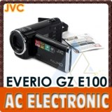
The black JVC GZ-E100 Full HD Everio Camcorder shoots Full HD 1920 x 1080 video. It features an SD/SDHC/SDXC memory card slot, back-illuminated 1/5.8" 2.5-megapixel CMOS image sensor and Konica Minolta HD lens. The high-quality HD lens supports 40x optical zoom, 70x Dynamic Zoom...
AC Electronic Ltd
- 999077 - HongKong
- +85 2 23 25 18 67
- +86 13501567844
Reportar abuso

Tuesday 07 July 2026
Cantidad : 20 Unit - Precio : $836
Price: US $836 Site: azriadi.com Accept paypal The SP31 included an improvement to the ASICs that delivered more hashing for the same power consumption. With the SP35 we replaced the PSUs to squeeze out even more out of the RockerBox ASICs. This new design will deliver 5.5TH/s...